
MICHELLE'S ADVENTURES
Fishers Peak State Park Trails

History
In April 2020, Fishers Peak State Park was established. Located in Trinidad, Colorado, the newly formed state park is the second largest state park, with 19,200 acres of rugged and varied terrain, and features the prominent Fishers Peak (elevation 9,632'). The park is an important wildlife corridor and is home to numerous wildlife species including mountain lions, black bears, elk, mule deer, raptors, and several rare/endangered species (e.g., New Mexico meadow jumping mouse, peregrine falcon).
The park is currently under development, with trails being added continuously. To learn more about the park's vision, check out the master plan and the park's FaceBook page. If you have input on the trail development or trail use, you can provide your comments to the planning team here. To volunteer to help with trail work, contact the Trinidad Trail Alliance.
Directions
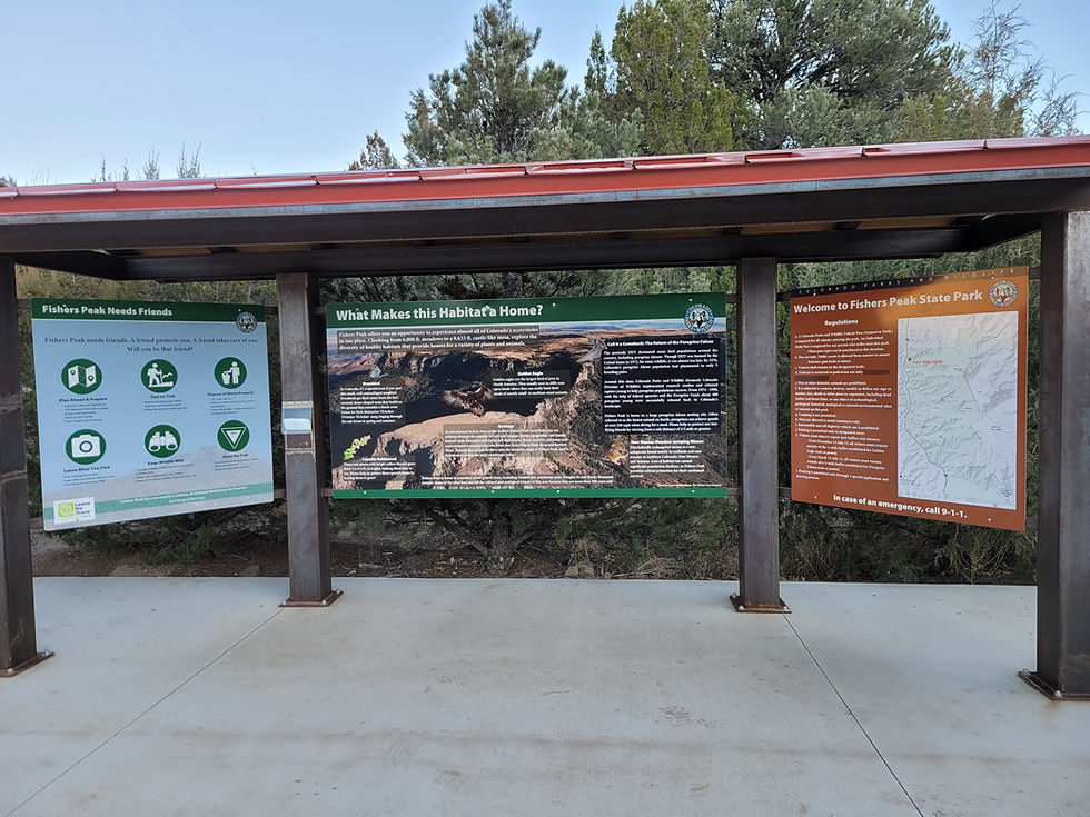
The gates are locked at 5:00 p.m. so make sure you are out of the park by then. Park passes can be purchased at the automated kiosk in the parking lot, in-person at the Trinidad Lake State Park, in conjunction with your vehicle registration (CO residents) or online. To reach the park take I-25 to Exit 11. At the rotary head to the east side of the highway (near the gas station) and turn right onto the frontage road (there is a park sign). The park entrance is on the left side of the frontage road. Currently, dogs and horses are not allowed in the park.
Park Map
The Hikes
1. Lower & Upper Lone Cub /Fishers Peak Trail Loop (~4.46 miles)
2. Goldenrod Loop (~6.51 miles)
3. Osita Peak Trail (~8.2 miles)
4. Fishers Peak Summit (~16 miles) NEW!
Lower Lone Cub - Upper Lone Cub - Fishers Peak Trail Loop
December 11, 2022
Total Length: ~4.46 miles
Elevation gain: ~847
Average hike time: 1.5 hours
It was one of those perfect Colorado winter days-sunny, in the low 60s, with no wind and I had to seize the opportunity to explore the new trails at Fishers Peak State Park.
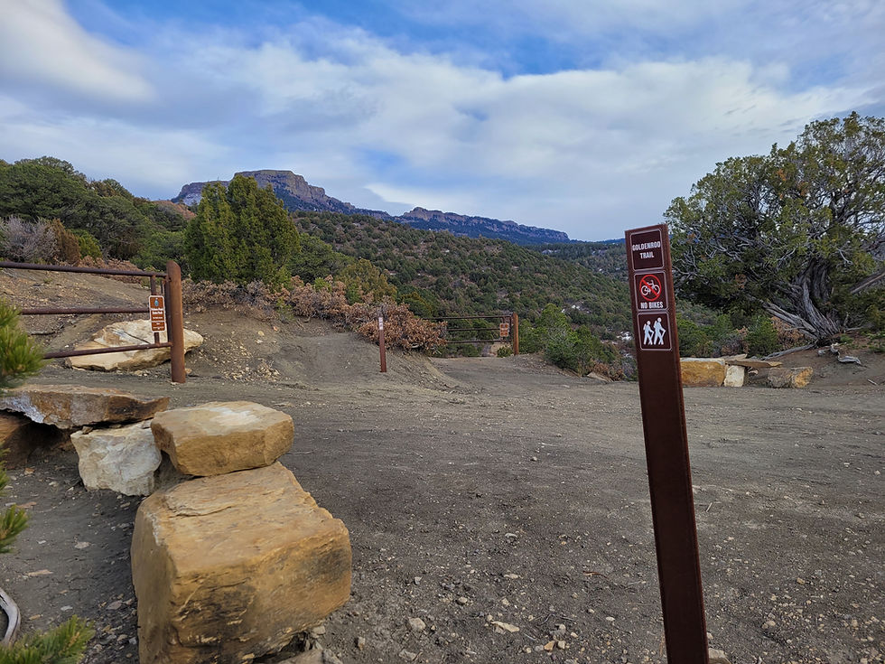
When I arrived, I was surprised to only see two other cars at the trailhead, but glad to have the trails mostly to myself. The parking area has excellent signage, clean rest rooms, and an automatic kiosk. The sign states that horses and dogs are not allowed in the park, so you will need to leave your furry companion behind. :( After going through the main gate, I followed the level gravel road for a few minutes until I reached an intersection. From here I could continue straight up the Fishers Peak Trail (a.k.a. Challenge Trail), turn left up First Look/Golden Rod, or veer to the right over a bridge onto a trail called Lower Lone Cub Trail. This intersection made me recall the lines from my favorite Robert Frost poem: Two roads diverged in a yellow wood, And sorry I could not travel both , And be one traveler, long I stood, And looked down one as far as I could, To where it bent in the undergrowth. I headed right, crossing over the new wooden bridge, and past a sign indicating the trail is for hiking and biking only.
The new trail is beautifully designed (huge shout out to the park staff, and to all the volunteers who donated numerous hours of labor to make this happen). It is mainly hard packed dirt complete with a few man-made rock crossings in the dips. The trail winds gently uphill through a blend of pinon and junipers trees. The incline is gradual with numerous switchbacks. The shaded sections were really icy, but the majority of the trail was easily passable. According to my Strava app, at about 0.98 miles from the main gate there is a second wooden bridge, after which views of the Spanish Peaks and Sangre de Cristo range appear. At around the one-mile point, there is another intersection. To the right is a "bike only-downhill only" trail called Poison Canyon.
I kept left onto Upper Lone Cub Trail which heads towards Fishers Peak and soon beautiful views of the peak emerged, with an expansive canyon on the right. The switch backs become a little tighter as the trail gently climbs uphill, eventually passing by some really cool rock features called hoodoos.
The trail continuously gains elevation until, at 3.05 miles, it reaches the trail hub. This well-designed trail intersection has several rock benches and spectacular views of Fishers Peak. From here you can return to the parking lot via Goldenrod (~5.1 miles), back down Upper and Lower Lone Cub trails (~3 miles) again, or via the steep Fishers Peak Trail (a.k.a Challenge Trail) (~1.4 miles). To extend the hike you can continue on Fishers Peak Trail (multi-use) to Osita Point, or all the way to the summit.
The temperature had dropped significantly, and the wind had picked up, so I put on a warm down jacket before resuming my hike. I headed back to the parking lot via the Fishers Peak Trail which is a steep (900ft elevation /mile). At least one third of the trail was fully shaded and very icy. Walking in the crunchy snow provided better traction and I was glad I had my hiking poles. At several spots there are impressive views of the Spanish Peaks, Sangre de Cristo range, and Trinidad Lake. The trail flattens out as it nears the Lower Lone Cub trail bridge.
The entire hike was approximately 1 hour and 45 minutes. Everyone's speed is different, but at a relaxed leisurely pace, and without the icy sections and stopping for notes/photos, I estimate it would take about 1.5 hours to complete the loop.
Update: January 7th, 2023, I did this loop in reverse and liked it better than doing it counterclockwise. The steep climb up the Challenge Trail to the trail hub offers a great work out, and the longer return hike down Upper and Lower Lone Cub trails are easier on the knees. However, when I'm pressed for time, I just hike up and down the Challenge Trail (35-40 minutes up and 25-30 minutes back down).
Lower Lone Cub->Upper Lone Cub->Fishers Peak Trail Gallery
click image to enlarge


Goldenrod Trail Gallery
click to enlarge images
Goldenrod Loop
Date: December 18, 2022
Total length: ~6.51 miles
Elevation gain: ~1,092
Average hike time: 2 hrs 30 minutes
I knew the holidays would involve a lot of sitting around, eating, and enjoying some cocktails, so I wanted to get a hike in beforehand and the Goldenrod Trail seemed like the perfect option. The Goldenrod Trail is a new loop that initially heads north then slowly circles to the east, and then south back to the trail hub.
From the parking lot I headed up the main trail for about 800 ft until I reached the intersection of Lower Lone Cub Trail, Fishers Peak Trail (formerly known as the Challenge Trail) and the Goldenrod Trail (called the First Look Trail on the trail sign). After reading the informative sign, I turned left. It was a little confusing because the trail sign reads First Look Trail with no mention of Goldenrod, so initially I was not 100% sure I was on the correct trail. This narrow scenic trail climbed moderately for about 0.3 miles, with several switchbacks, until it reached the overlook point on the right. The views of the peak from this point were beautiful and it is a great place to stop and take a photo. Just after the overlook there is a Goldenrod Trail sign.
I continued onto a trail that now was clearly marked the Goldenrod Trail. The trail had a few sections with rocky steps and switchbacks. After the steps views of the Sangre de Cristo Mountain Range emerged and between mile markers one and two, views of Fishers Peak and Trinidad Lake come into view. The trail was more gradual here with some gentle switch backs. Tall trees provided shade and the trail had widened to about the width of an ATV.
The trail was flat in several sections where it followed the elevation contour. After mile marker 3, I did not see any other mileage markers. The trail kept curving around clockwise. I continued for approximately two more miles before reaching the trail hub where the Fishers Peak Trail (hiking only), Fishers Peak Trail (multiuse), and Upper Lone Cub Trail all converged. (I will note that shortly before the hub, there was a spot where the trail continued slightly up hill (wider path) and there was a turn to the right (narrower path). I didn't see any signs and so I took a chance and veered right and reached the trail hub. I think either path will lead to the hub.)
According to my Stava app, the total distance from the parking lot to the trail hub was 5.11 miles with a 1,092' elevation gain. From the hub I took the steep ~1.4-mile-long Fishers Peak Trail (hiking only) back to the parking lot. If I had more time, I would have retuned back to the parking lot via the Upper Lone Cub and Lower Lone Cub Trails since they are a little less steep and (in my opinion) more scenic.


Osita Point
Date: January 13, 2023
Total length: ~8.36 miles
Elevation gain: ~1,837ft
Average hike time: 3.5 hrs
Today it was a warm sunny day- perfect for hiking to Osita Point. From the parking lot I headed 1.4 miles up the steep, aptly named, Challenge Trail. This section of trail has ~900ft elevation gain, so it is a great workout. (Note: my Stava app is convinced the elevation gain is only 778'.) Once I reached the trail hub, I continued straight onto Osita Point trail. (Depending on the language, osita has several meanings, but in Spanish it means little bear.) This beautiful trail has a gradual incline, and in most places, is the width of a standard hiking trail. The trail appears well used by both hikers and bikers. After the trailhead there is absolutely zero signage, so there is no way to discern if you are still on the correct trail or how many miles you have hiked.
For the first part of the hike, I had a Townsends Solitaire for company. Although he never showed himself, his clear, single one syllable notes were unmistakable. (For those of you who enjoy birding, I recently discovered the free Merlin app which allows you to record a bird call and it will tell you the species with really decent accuracy.) The trail winds back and forth providing stunning views of the Spanish Peaks, the Sangre de Cristos, Trinidad Lake, the city of Trinidad, and Fishers Peak. My favorite section of the trail passed through a stand of old ponderosa pine trees. (If you have a minute, stop and smell the bark of an older ponderosa pine trees-many have a vanilla or butterscotch fragrance).
After the ponderosa stand, a view of what I assume is Osita Point emerged. It looked like there were a few switch backs and that I would be at the top in no time, but it is deceiving. The trail actually continues much further and approaches the point from the back side. After passing a large group of rocks on the right-hand side, the trail turns left uphill into a forested area and then seems to stop at a large ponderosa. There are some "do not enter" signs on a wooden fence. To the left there is a faint path that heads upwards through the trees. This might be the place where bikes are no longer allowed and Osita Trail starts. Unsure, I followed the trail uphill, over some steep stair sections, to the top where it made a small loop. There were not really any big dramatic views or places to sit, so I headed back down the trail.
So far this has been my favorite hike because of the variations in terrain (open trails, old ponderosa, rocky out cropping, and a diversity of views); however, it is the longest of the trails so allow extra time. According to my Stava app, the Challenge Trail section was 1.4 miles one way (with an elevation gain of 778'), and after leaving the trail hub the distance to Osita Point was 2.78 miles (with an elevation gain of 1,059') for a total of 8.36 miles round trip and total elevation gain of 1,837'.
Osita Point Gallery
click to enlarge


Hike to Fishers Peak Summit
Date: September 4, 2024
Total length: ~16 miles
Elevation gain: ~3,400 ft (per my Strava app)
Hike time: 7.5-8 hrs RT
Closed mid-March to late August
Since moving to Trinidad in 2009, I had always wanted to hike this iconic peak, and once CPW completed the trail to the summit, I finally had my chance. I knew it would take me a long time (I'm a slow hiker) so I ventured out at sunrise with plenty of water, some snacks, and other hiking essentials.
After leaving the parking lot there was a flat ~0.5 mile section of gravel road that led to the start of the Challenge Trail. The aptly named Challenge Trail was a steep ~1.2 mile uphill slog on an old jeep road with an elevation gain of ~770 ft that culminated at a thoughtfully designed trail hub, complete with a central stone wheel. This section took me around 40 minutes and I rested at the hub on the conveniently placed stone benches and admired the view of Fishers Peak before proceeding.
The next 2.3 mile portion of the trail headed to Osita Point. There was a gradual elevation gain, open views, and several gentle switchbacks. At the base of of Osita Point was a small clearing with a tall ponderosa pine. I skipped the shot spur trail that leads to the top of Osita Point (been there/done that), and instead, rested, hydrated, had a snack, then continued
Shady Forest was perhaps my favorite part of the hike. I loved the tall trees, the scent of the pines, and the way the light filtered onto the forest floor. This ~1.8 mile section was gradual, with minimal elevation gain and lots of shade (as indicated by its moniker). At the end of the Shady Forest there was a gate that the park closes when the peregrine falcons are nesting. Only 1.5 miles to go!
The portion of the trail beyond the gate is called the Stone Guard. Here the trail exited the cool forest and the landscape opened up. The sheer cliff walls towered over the open area and appeared rather daunting. The trail climbed steeply via a series of switch backs towards the summit. The well-maintained trail had some steep drop offs, so I had to stay focused on the trail and not get too distracted by the dramatic views. The last push to the the summit was through a crevice in the rocks and I actually needed to use my hands here for stability.
Finally, I was on the top of the iconic peak! The 360 degree views of the surrounding area were incredibly rewarding and I enjoyed the short half mile loop around the summit. As I started the trek back down, I realized how tired I was, and I knew the eight mile return trip was going to be tough.
Overall, this was a strenuous, yet rewarding 16-mile long hike with an ~ 3,400 ft elevation gain. If I do this hike again, I will definitely bring extra water (I was out by the time I reached the summit) and a back up battery (my phone died on the way back). I really appreciated having hiking poles, especially on the way down. I think checking the weather forecast (esp. for thunderstorms), getting on the trail early, and hydrating is a recipe for success. With all my rest breaks and photo stops it took 4 hrs 20 min to summit. Coming back down was faster but my phone died so I could not map it on my Strava for the exact time but it was under four hours).
Fishers Peak Summit Gallery
Click to enlarge photos


Safety & Gear
It is important to consider safety, even when hiking short trails. Hikers can encounter a range of potential dangers on Colorado trails including bears, lions, rattlesnakes, lightning storms, snow and hail. Colorado is notorious for afternoon thunderstorms in the summer. Furthermore, it is possible to sustain an injury from tripping or to become lost. So, know your route, check the weather forecast, tell someone where you are going and when to expect you back (stick to that plan), allow yourself sufficient time, and carry the appropriate gear. Dress in layers since Colorado weather can be unpredictable and avoid wearing cotton.
Check out the short hike packing guide
:
* small backpack
* Osprey bladder or
Nalgene bottle
* cell phone
* backup battery
* first aid kit
* Garmin InReach
* pocket knife
* compass
* spare laces
* map
* raincoat
* warm hat
* bear spray
* headlamp
* spare batteries
* sunscreen * sunglasses
* sun hat
* Hiking poles